| CC4HH
The Battle of Tewkesbury
This project was conducted by: Mike Barnes, Michael Holmes, Laura Hunt, Shauna Ralph, Becky Turner.
Our group investigated whether the Gastons field in Tewkesbury played a major part in the Battle of Tewkesbury in 1471, which was a crucial moment in the Wars of the Roses.
Jump to: Timeline | Legacy of the Battle | The Gaston’s of Tewkesbury | Excavation
Timeline
The Wars of the Roses saw years of conflict for the throne between two royal families – the House of York and the House of Lancaster. The Battle of Tewkesbury took place on 4 May 1471 and it marked the end of the second phase of these bloody battles.
14 April 1471: Queen Margaret lands at Weymouth with her second army.
The Lancastrians headed for Gloucester, but couldn’t get. They headed for Tewkesbury instead – they found that Edward IV’s army were too close to allow for escape.
4 May 1471: Soldiers began to prepare their weapons.
The Lancastrian and Yorkist forces began dividing their armies into three sections.
Edward made a tactical decision to hide 200 spearmen in bushes at Deer Park. When the battle began, the Lancastrians were immediately outnumbered.
Somerset directed his men to attack the Yorkists from the rear, but were driven back and crushed by Yorkist spearmen.
As the Yorkists advanced, the Lancastrian line broke and many of them fled.
However, they were trapped by the river and many of them were killed at the Bloody Meadow – including the Prince of Wales.
The Lancastrians reached Tewkesbury Abbey and tried to claim sanctuary, but the Abbot refused them.
The remaining Lancastrians were executed and Queen Margaret was captured.
Her family in France paid a ransom for her release and the Yorkists claimed victory over the battle.
The Battle of Tewkesbury saw a crushing defeat for the House of Lancaster with the death of the Prince of Wales and the capture of Margaret of Anjou. Thus, it saw all hopes of a Lancastrian succession diminish.
The legacy of the battle

The ‘Arrivall’ sculptures were commissioned by the Tewkesbury Battlefield Society, created by Phil Bews, Diane Gorvin, and children from Tirlebrook Primary School. They represent the conclusion of the battle where the Yorkists defeated the Lancastrians. The sculptures guard the Stonehills roundabout off the A38, Gloucester Road.
Find out about the Tewkesbury Battlefield Society, the sculptures, and who funded them on the Tewkesbury Battlefield Society’s website.
The Battle of Tewkesbury remains a significant part of Tewkesbury’s history and heritage, ever more so as we approach the five hundred and fiftieth anniversary in 2021.
For more information about the annual Tewkesbury Medieval Festival visit their website.

“The Battle of Tewkesbury is part of what makes Britain what it is, even if it is a small part. You can’t celebrate something like this, you have to commemorate it.”
– Steve Goodchild, Chairman of the Tewkesbury Battlefield Society
See for yourself
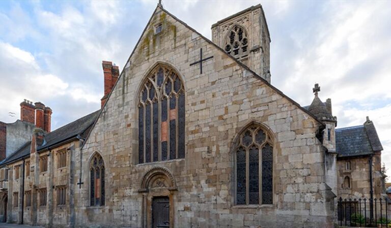
Throughout Tewkesbury, there are many sights that both represent the battle and the medieval period in which it took place. These include Tewkesbury Abbey, ‘The Arrivall’ and Gupshill Manor.


“On this sad Spot — the royal Margaret chose, With her brave Son — to wait her coming Foes! Yon sacred Pile, in awful grandeur stood, As if to turn their thoughts — to Peace — from Blood. Could some bless’d shade have whisper’d — from the tomb, To warn her of her noble Child’s dire doom.”
– Cecilia Cooper, 1820
The Gastons’ of Tewkesbury

A Gaston is an enclosed area of meadow.
The land was first given this name around 1540, in Leland’s Itinerary.
Leland’s is perhaps the only surviving pre-1900 commentary suggesting ‘The Gastons’ as the site of the Battle of Tewkesbury.
The land was first given this name around 1540, in Leland’s Itinerary.
Leland’s is perhaps the only surviving pre-1900 commentary suggesting ‘The Gastons’ as the site of the Battle of Tewkesbury.
The area known as ‘The Gastons’ would have been significantly larger.


We know this from the 1632 Survey of Abbey Lands ‘The Gastons’ are described as “Pasture grounde now divided into 2 parts…’ totalling 41 acres – 1 rod 29 perches.
Excavation
What was the nature of our dig?
To explore the location of the battle and finding evidence from that period which aided us to pinpoint parts of the battlefield.

Trench 1 was placed near a stream at the bottom of the Gastons field. We discovered evidence of ridge and furrow plough marks across the field.
In addition, to the natural slope of the field towards the river, we speculated that artefactual materials may have shifted towards this area.
Trench 2 was a little further upfield. A large patch of nettles was growing in this area, which can grow around disturbances and activity in the earth.


Trench 3 was located using the previous survey work. An earlier metal detecting survey produced a significant number of metallic objects in the area.
Due to the nature of metal detecting, ceramic or organic materials could have been missed and remain in the ground at this point.
The search begins
Having removed the grass turf, we began trowelling the ground. We carefully trowelled the soil hoping to find anything of interest. Using a delicate tool we were able to see changes in the soil, which might provide evidence of human activity.
Our findings:
Trench 1 – We found two small, round depressions. These could be post holes, where wooden stakes were placed in the ground: Could this be evidence of one of the Battle of Tewkesbury campsites?

Trench 2 – In addition to clearly defined stratigraphic changes in the soil and lots of charcoal. Two objects were discovered: a nineteenth-century piece of pottery and an iron nail – the nail could be medieval in origin.

Trench 3 – We found lots of charcoal which potentially indicates as evidence of burning. This could suggest a popular agricultural practice used up until the twentieth century known as ‘stubble burning.’ However, we also found a curved line of charcoal, which could also indicate the presence of a fireplace or firepit.